Navigating Nothing
Eric Larsen
10 March 2017 | Somewhere, Mongolia
When we stopped for our resupply 'J' had told us to stay to the left and head toward the lake once we were out of the canyon.
Throughout our journey, we relied on Balu's encyclopedic memory of the trails and roads (if you can call them that) across the Gobi and J's translation. For the most part, he was nearly 100% accurate. However, the hard part for us came when trying to match the verbal information with what we were seeing in front of us.
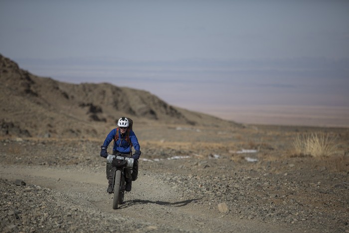
But first let me share a little newly learned knowledge about Mongolia's road system. Out of a total of 50,000Km of roads in Mongolia, only about 5,000Km (10%) are paved roads. The rest are gravel and dirt roads often consisting of just a couple of ruts (or faint tracks). Because much of the Gobi is wide open terrain as soon as one set of tracks gets too rutted drivers simply shift over a few feet and start a new 'road'. On popular routes, we often saw four or five sets of older tire tracks paralleling the most current version. In many areas, drivers often take short cuts further confusing the mix. Main roads connecting villages can often look like a road going to a ger as well. Finally, and probably the most vexing to us, is that there simply aren't any road signs.
So, when Tim and I woke up this morning and starting riding down hill toward the lake, we wondered at which point we should veer left... the first left that was immediately after a cairned 'intersection' or the second left that clearly veered toward the lake, however, so we followed J's instructions and veered left.
Before us was a beautiful panorama (is there really any other way to describe the Gobi) rolling down to a huge frozen lake. The ride was mostly down hill but with a head wind. We knew this would be our last day of riding so we tried to soak in as much as we could. We passed a large herd of goats and sheep. Then, a man riding a camel. The wind was cold, but the sun was warm and even though our legs were tired, we raced on hoping to reach the lake.
Then we began to wonder where Balu and J were with the van. They were supposed to pass us at some point in the morning. We had been riding for several hours but still didn't see them. The lake was bigger than I had imagined and our road was taking us to the southeast end. While we couldn't tell, the main road looked like it veered more to the North end of the lake.
In the end, we had gone the wrong way - taken the wrong veer out of several wrong turns. Balu and J had followed our distinctive bike tire tracks in the sand and dust. The day prior Balu had said, 'don't worry, I'll find you.' and he remained true to his word.
Reunited, we loaded up the bikes for the final time and drove down a thin motorcycle trail bouncing toward the main road. When we turned off the main road again toward the lake on what clearly was just a dead end, I asked J, 'Is this a short cut?'
'No,' he replied. 'This is the main road to town.'
Image: Tim on one of the more distinct roads.