Day 20. How it all works
sunny warm, afternoon snow, 32 degrees F
21 September 2010 | Everest Base Camp, Nepal 17,642 ft (5,377m)
I'd like to say I was the one ultimately responsible for bringing Everest to your living room or office, but the reality is I am simply the person behind camera lens and keyboard. Sending images, video, blog posts, tweets, status updates, gps coordinates and more to is the result of a process much too complicated for me to comprehend, but luckily for me, pretty easy enough to use; and consequently, explain.
Most of my web presence is the brainchild of webExpeditions founder Tim Harincar who developed a program called XJournal. Through this program, I am able to send an email update with attached photo, gps position and a few other odds and ends that automatically updates my web site, Facebook page, Twitter and marks my position on a map (I know that's a mouthful, right?). This is really the 'meat' of what I do daily and a big part of how I try to connect you to these 'last great frozen places'. My goal is to have you understand how incredible and beautiful these places are, and ultimately, how delicate and fragile they are as well.
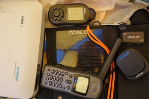
The fact that I can send a daily email from a place with no infrastructure whatsoever is no small feat, either. Each day, I tap out my daily blog into a small palm top computer. Next, I connect that device to my Iridium phone with a special serial cable, wait for a good signal and send! That part is relatively easy, and with a steady source of power supplied by Goal0's solar panels is relatively easy. All, I need to do is find something to talk about or share each day, but honestly, that's pretty easy. This place is amazing. Sure there are days that I would much rather curl up in my sleeping bag and go straight to sleep, but then I remember, my mission.
Audio updates are also processed without any human interference. I simply call into a Vonage voice mail box where it is process and posted on my web site. Pod casts are currently manually linked in Facebook just because of the simple fact that they will appear with an embedded player so they are easier to listen to. Hope you enjoy that little bit of convenience! I know I do.
Mapping is another unique aspect of the XJournal program. These are also updated automatically and through one of two different ways. First, I simply turn on my DeLorme GPS and type my latitude and longitude into my daily report. Pretty easy. The other way is even easier and I use the SPOT 'Check In' function on my DeLorme unit. XJournal takes this information and posts my position as well as a message to Facebook and Twitter.
Different than the poles, I am also able to use another satellite network to upload larger files (photos and videos). These go directly to Elisabeth, my expedition manager which are then loaded to Facebook, YouTube and sponsors. I also send out images to Scream Agency who helps distribute these images, real time, to media outlets as well.
OK, bear with me, I'm almost done here. The last component of all this Everest story telling is that all the data that I send into webExpeditions is geotagged with latitude and longitude so it can be view in Bing Maps (or other online mapping programs). So, as you can see, it is more than just me responsible for bringing you the story of the Save the Poles expedition. While what I have been doing hasn't really changed much in 10 year, my ability to share it has. As has your ability to interact with this information and share it with others. (Hey since we're on the subject, please ask your friends to join my fan page http://facebook.com/ericlarsenexplore). Not only is it my expedition, PR and tech team that are helping promote the Save the Poles story, but also have partnerships with several other organizations to help bring you a better understanding of the issues surrounding climate change.
This week, Katie Mandes from the PEW center for Climate Change provided this insight which is attributed to Dr. Jay Gulledge and discusses climate risks and extreme weather.
To learn more about how vulnerable we are to extreme weather events and how we can manage the associated risks, click here:
Image: Some of the gear I use to send daily updates.